Earthquake Engineering
Introduction
The core task of earthquake engineering is the seismic design of structures for the earthquake load case. It is checked whether the existing structure capacity is sufficient to absorb the earthquake action present at the structure site.
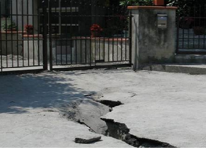
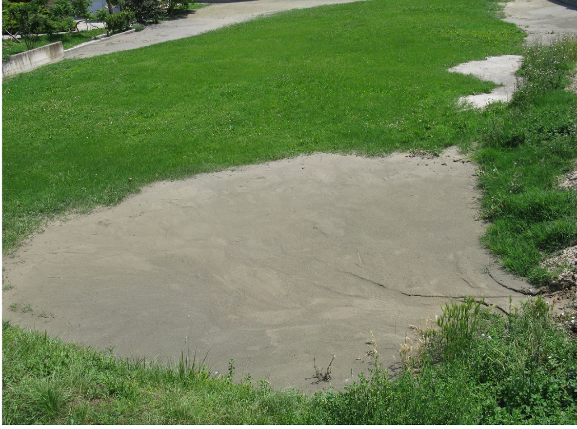
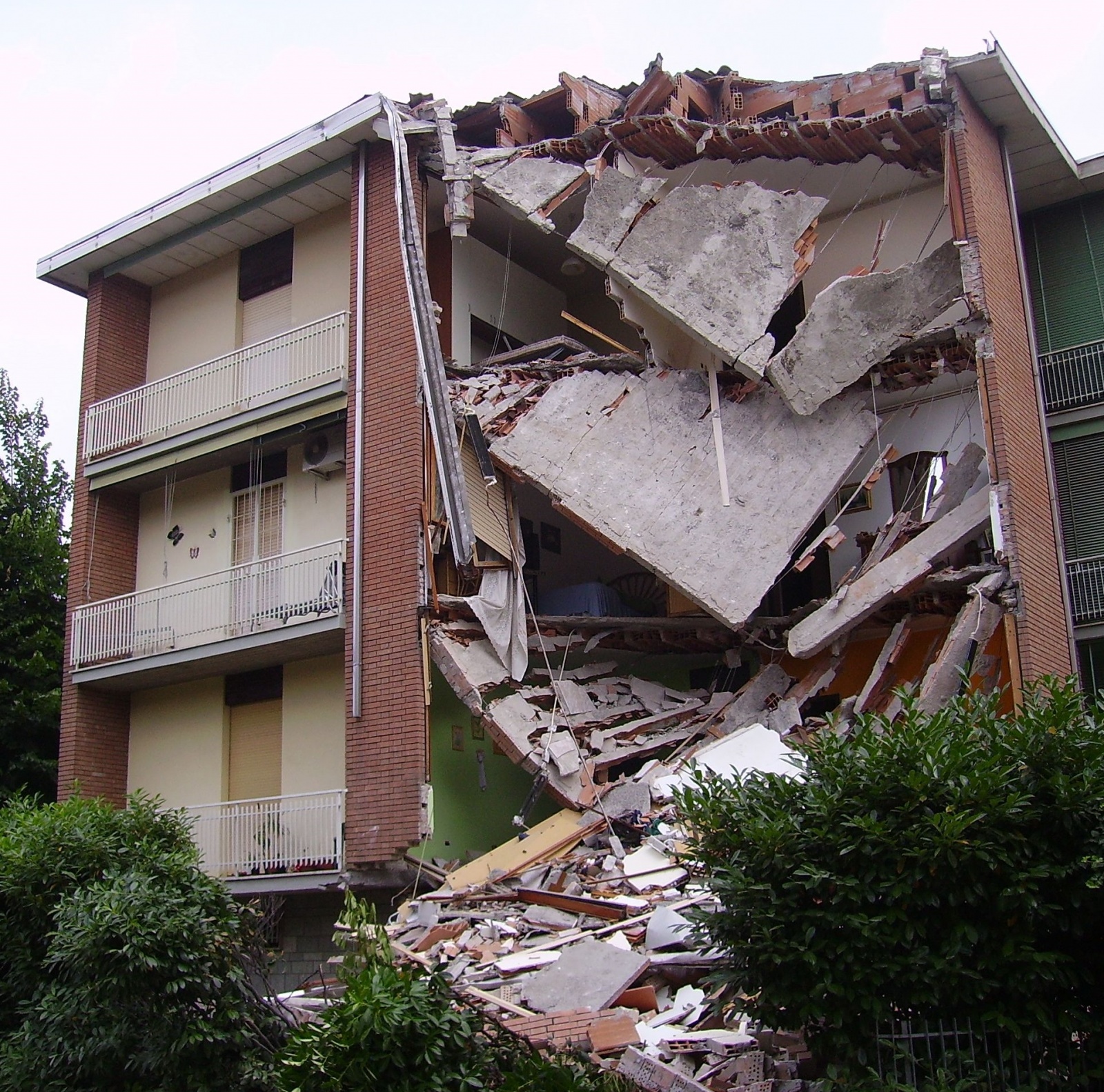
The stability of structures can be compromised by geotechnical effects in the subsurface and by dynamic inertial forces induced in the structures. The following damage patterns resulting from the series of earthquakes in Emilia Romagna, northern Italy in 2012 illustrate possible damage effects of earthquakes.
Subsurface effects
Ground motions resulting from earthquakes can lead to soil liquefaction effects due to a loss of shear strength of the soil. Furthermore, faults can occur at the earth's surface. Both effects endanger the stability of structures.
Structural damage
Structures that are not designed to withstand earthquakes can suffer serious damage, including partial or total collapse of the structures.
Earthquake science
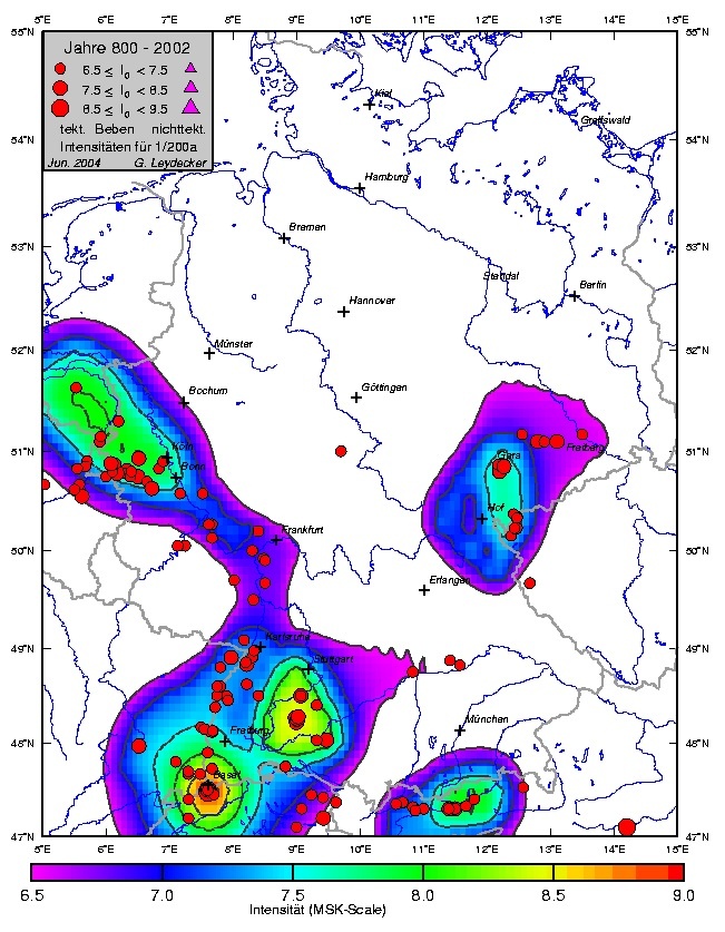
The effects of earthquakes are described by earthquake hazard maps, which can be used to determine site-specific earthquake hazards. Earthquake hazard maps are usually based on probabilistic hazard analyses using historical earthquake catalogs and geophysical models. The hazard maps can be produced for different return periods. The following map shows an example of an intensity-based hazard map for Germany with a return period of 2500 years, which was created by Leydecker.
In the further subsections the earth structure, the plate tectonics with the seismic wave propagation and the essential seismic and physical parameters are explained.
Earth structure
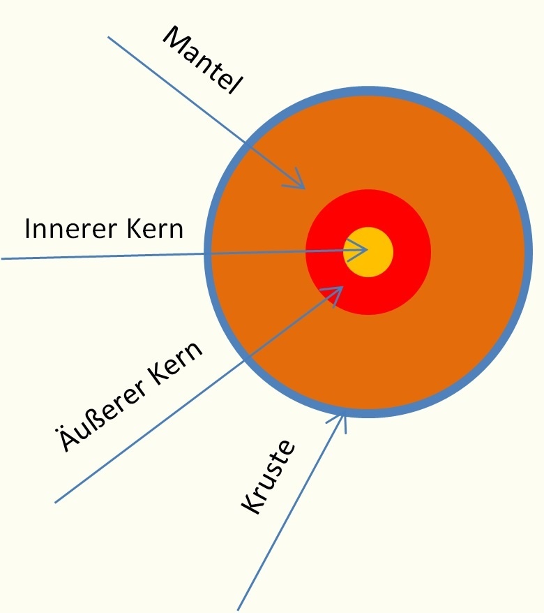
The earth's body with a diameter of about 12,740 km consists of different layers with strongly varying material properties. The layers can be subdivided according to the figure into the earth's crust, the earth's mantle, and the earth's core. Within these layers a further subdivision can be made:
- The crust is divided into upper (continental) and lower (oceanic) crust.
- With the mantle one distinguishes between upper, middle, and lower mantle
- The core consists of outer and inner core
Earthquakes are caused by the displacement of individual plates in the upper mantle (the lithospheric plates) due to thermal expansion processes in the lower mantle. The individual plates move with different speeds and directions due to different densities of the crust and the mantle.
An important aspect for the physical description of the seimological processes are the wave velocities in the layers of the earth's body, which are compiled in the following table.
| Crust | Upper crust | Depth 10-30 km, wave velocity: up to 6.3 km/s |
| Bottom crust | Depth 6-10 km, wave velocity: 6.4 -7-4 km/s | |
| Mantle | Upper mantle | Depth <400 km, wave velocity: 8.0 -8.3 km/s |
| Middle mantle | Depth 400 -900 km, wave velocity: < 11km/s | |
| Bottom mantle | Depth< 2900 km, wave velocity <13.6 km/s | |
| Core | outer core | Depth < 5100 km, wave velocity 8.1-9.4 km/s |
| inner core | Depth < 6370 km, wave velocity 11.3 km/s |
Plate tectonics
The Earth's mantle consists of seven major plates and a large number of other smaller plates. The plates under the oceans are called oceanic plates, those under the continents are called continental plates.
Due to the increasing heating of the Earth's core, heat-induced plate movements occur in the deeper layers. The "floating plates" move away from each other, toward each other, or past each other. The movements are usually very slow.
When two plates collide with each other, faults can form that are visible on the earth's surface through cracks. Dynamic movements of the plates on these faults cause earthquakes. The following types of faults are distinguished:
- Displacement
- Horizontal displacement
- upshift or overshift
In reality, mostly mixed forms of the listed faults occur.
Seismic waves
Earthquake Generation
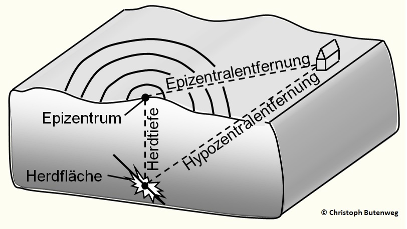
Earthquakes are caused by sudden geological fractures in the earth's crust, which moves as a system of rigid plates on the softer interior of the earth. The entire system is in constant motion, causing stress changes in the earth's crust. When the resulting stresses exceed the fracture strength of the rock, sudden fractures with jerky movements occur, resulting in tectonic earthquakes. The following figure shows the chain of action set in motion by the fracture surface (focal surface).
The vibrations generated in the center of the focal plane (hypocenter) propagate as seismic waves to the earth's surface, whereby the waves arriving at a site are decisively influenced by the composition of the propagation medium with respect to their amplitude and frequency content.
The projection of the hypocenter onto the earth's surface is referred to as the epicenter of the earthquake, and the distance between a site and the epicenter is referred to as the epicenter distance. The term hypocenter distance is also often used, indicating the distance between the site under consideration and the hypocenter. Solid lines in the figure represent the isosections on which the same magnitude of shaking is felt.
Seismic waves
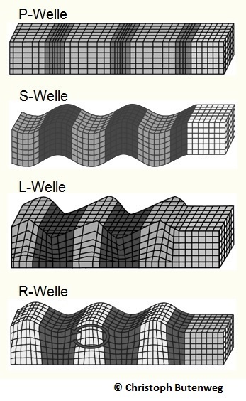
Seismic waves can be divided into spatial and surface waves, with the former distinguished as compression and shear waves. Compressional or primary waves (P waves) cause particle motion parallel to the direction of wave propagation and have a higher propagation velocity than shear or secondary waves (S waves), which cause particle motion transverse to the direction of propagation.
While space waves can propagate in a solid or half-space, the generation of surface waves, of which Rayleigh and Love waves (R, and L waves, respectively) are the most important representatives, is tied to the presence of a boundary surface (such as the Earth's surface). The amplitudes of the surface waves decrease exponentially with depth.
The figure shows the different types of waves, of which primarily the vertically propagating shear waves cause structural damage.
Seismic quantities
Seismological labeling of earthquakes
Scales based on instrumental or non-instrumental quantities are used to label the magnitude and damage effects of earthquakes. Instrumental quantities are, for example, magnitudes or seismic moments; non-instrumental quantities are usually referred to as intensities.
Magnitude Scale
Magnitudes are dimensionless logarithmic measures of quake magnitude. For practical purposes, the local magnitude ML is of particular importance, since it describes well the conditions for earthquakes with focal distances up to about 1000 km, which alone are decisive for German conditions. There are empirical relations between the seismic energy of the earthquake and its local magnitude, such as the following relation, which goes back to Kanamori and is valid for the magnitude range from 1.5 to 6.0:
log E = 1.96 ML + 2.05 [joules = 107 erg].
From the formula, it is clear that when the local magnitude increases by one, the energy of the earthquake increases by a factor of 91. Earthquakes with local magnitudes smaller than about 2.5 are hardly noticeable and are called microearthquakes. The strongest local magnitudes are about 6.5 to 7; for stronger earthquakes, other measures such as space wave magnitude, surface magnitude, or seismic moment are useful. Since magnitudes describe only the energy released at the focus, they say nothing about the effects of the earthquake at a particular location, which may be closer or farther from the epicenter.
Intensity scale
Unlike magnitude, intensity is a measure of the locally felt strength of an earthquake, characterized by its effects on people, structures, and the landscape, and thus is not an instrumentally determined quantity. The commonly used twelve-part scales have been developed over time.
Today, the European Macroseismic Scale (EMS scale) developed by Grünthal is mostly used in Europe. It is based on the Medvedev-Sponheuer-Karnik scale (MSK scale) and also takes into account further material-specific and constructional aspects of structures. The following table gives the classification criteria in a highly abbreviated form. The intensity occurring at a site is generally dependent on the following parameters in addition to the earthquake magnitude:
- Hearth depth
- Hypocentral distance
- Quake duration at the site
- Geological subsurface conditions
- Local ground conditions
- Frequency content of the earthquake at the site
| Intensity | Shaking | Description/ Damage |
|---|---|---|
| I | Not felt | Not felt except by a very few under especially favorable conditions. |
| II | Weak | Felt only by a few persons at rest, especially on upper floors of buildings. |
| III | Weak | Felt quite noticeably by persons indoors, especially on upper floors ob buildings. Many people do not reconize it as an earthquake. Standing motor cars may rock slightly. Vibrations similar to the passing of a truck. Duration estimated. |
| IV | Light | Felt indoors by many, outdoors by few during the day. At night, some awakened. Dishes, windows, doors disturbed; walls make cracking sound. Sensations like heavy truck striking builing. Standing motor cars rocked noticeably. |
| V | Moderate | Felt by nearly everyone; many awakened. Some dishes, windows broken. Unstable objects overturned. Pendulum clocks may stop. |
| VI | Strong | Felt by all, many frightened. Some heavy furniture moved; a few instances of fallen plaster. Damage slight. |
| VII | Very strong | Damage negligible in buildings of good design and construction; slight to moderate in well-built ordinary structures; considerable damage in poorly built or badly designed structures; some chimneys broken. |
| VIII | Severe | Damage light in specially designed structures; considerable damage in ordinary substantial buildings with partial collapse. Damage great in poorly built structures. Fall of chimneys, factory stacks, columns, monuments, walls. Heavy furniture overturned. |
| IX | Violent | Damage considerable in specially designed structures; well-designed frame structures thrown out of plumb. Damage great in substantial buildings, with partial collapse. Buildings shiftetd of foundations. |
| X | Extreme | Some well-built wooden structures destroyed; most masonry and frame structures destroyed with foundations. Rails bent. |
Physical quantities
Structural characterization of earthquakes
The seismic design of structures requires a quantitative description of the seismically induced ground motions. In addition to a number of other parameters in the time as well as in the frequency domain, response spectra have established themselves as the most important characteristic function in earthquake engineering.
Physical parameters
The decisive physical parameters for the characterization of ground motion are:
- Ground displacements
- Ground velocities
- Ground accelerations
- Frequency content of the ground motion
- earthquake duration
As time histories of ground motion, accelerations are usually measured. From these, curves of ground velocities and displacements can be calculated by integration. The frequency content of ground motion at a site is strongly determined by the geological subsurface. On rocky bedrock, short earthquakes with larger ground accelerations are to be expected, but these are accompanied by high frequencies, and thus have a relatively low damage potential. Thick sedimentary layers, on the other hand, cause a shift of the energy content of the wave field towards lower frequencies, in addition to longer quake durations and lower maximum ground accelerations.
Response spectrum
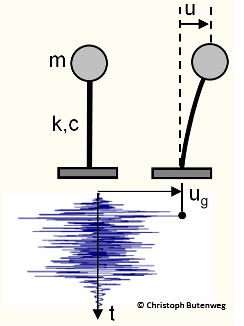
Response spectra are the most important function for describing the load action in the seismic design of structures. They give the response of single-mass oscillators as the simplest structural models to footpoint excitations with the respective acceleration time histories.
Response spectra are calculated by applying to a single-mass vibrator (stiffness k, damping c and mass m) the time history of a footpoint acceleration, as shown opposite. As a reaction, the maximum values of the relative displacement u, the velocity and the acceleration of the mass point can be determined by calculation.
If now the maximum values for single mass oscillators with different periods are calculated and plotted as a function of the eigen periods T, the corresponding calculated and plotted as a function of the eigen periods T, the corresponding progressions for displacement, velocity or acceleration response spectra are obtained. The ordinates of these progressions are called spectral coordinates.
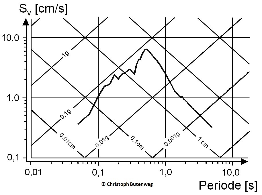
Instead of three different curves, it is recommended to draw one single curve in a double logarithmic diagram with the periods on the abscissa and the spectral velocities Sv on the ordinate, so that the spectacle acceleration Sa and the spectral displacement Sd can be read along coordinate axes rotated by 45°. As an example, the following figure shows the curve for the Roermond earthquake in 1992.
A particular advantage of this display method is that in the left part of the image (for very small eigen periods, thus very stiff systems) the (constant) maximum ground acceleration can be read, while in the right part (for very large eigen periods, thus very soft systems) the corresponding maximum relative displacement appears. This allows a quick check of the plausibility of the response spectrum.
The Current earthquakes
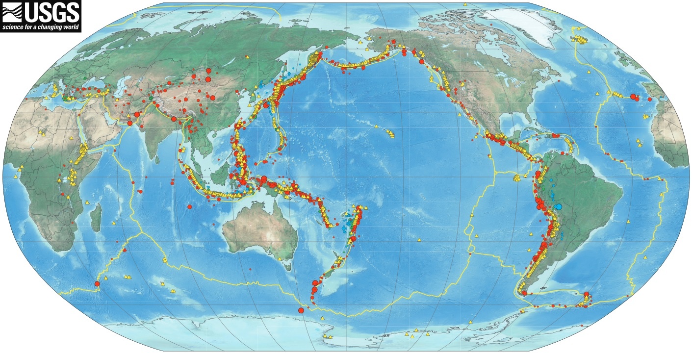
Earthquake activity is constantly monitored by measurement worldwide. Several international earthquake services make the data they record available online.
The Current earthquakes are provided on the following websites:
